Talking Election Day Blues: Something Better To Look At


Image result for ohio meets mississippi river

Where the Ohio meets the Mississippi, in race-burnt Cairo, IL. If it’s a metaphor, it ain’t a positive one. 

It’s election day, so let’s talk about rivers. 


It’s going to be sort of a strange election day for me, personally. I’ll be traveling for work this afternoon and have early meetings tomorrow. Not sure if I’ll be able to be liveblogging tonight. Who knows, maybe it is for the best. I expect Hillary to win, of course, but am still torn by that nagging fear that we’re finally living in that movie, that one where everything goes to hell, and this is the opening montage.

Can’t you see it? The flickering TV in the background, the snatches of newscaster voices “In a surprising upset, billionaire outsider Donald Trump has…”, followed by staticky shots of liberated militias whooping and hollering, riot police in the streets, jackbooting protestors, decrees of new laws, rivers of jagged-glass partisans facing off in the streets, fires in the streets…terrible, obscene images. A new pornography of terror, brought in by millions of people in ecstatic grade school libraries.

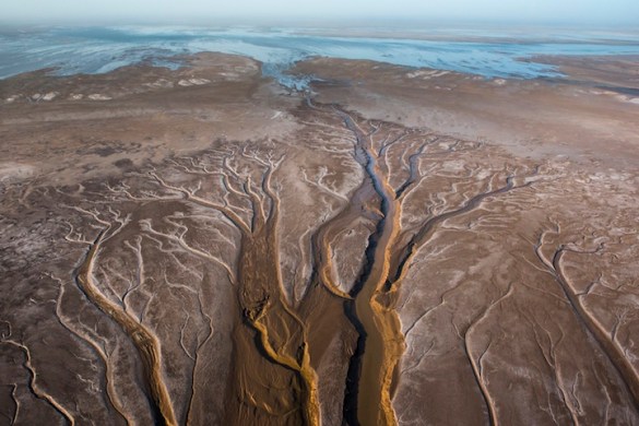
That’s why I’d rather focus on this. It’s a few months old, but I just saw it yesterday- it’s a representation, based on satellite imagery, of all the rivers that flow to create the Mississippi. It’s 21 seconds, and it is beautiful.

(From NASA Scientific Visualization Studio. H/T nationalgeographic.com)

Watch it start at the headwaters of the Missouri, just east of the Rockies, picking up steam through hundreds of tributaries. Watch the main branch start from seemingly out of nowhere in Minnesota, where tiny streams and small rivers from Canada begin to cut a path, as it twists and turns slowly before straightening.

It’s just as amazing to look at the major river systems of the east, and see how they all eventually pay homage. The wild and barely-tamed Tennessee, which runs itself north and south, around great bends and wild shoals toward the Ohio. The Ohio, which starts in Pittsburgh as the confluence of two other great rivers, the Allegheny and the Monongahela, which themselves receive tribute from a series of rivers and streams stretching to the border of the Great Lakes basin.

It is an enormity. It’s wonderful and beautiful to think that headwaters from a Pennsylvania farmers field or a stream near the Adirondacks or lazy mosquito-ridden swamps in a Minnesota summer and waters barely trickling through the badlands can all converge. The whole great middle of the country is, in ways that we can’t tell from our small experience, tilted that way. Every drop of water spilled in the whole vastness of the basin, if left untouched, will eventually end up in the Mississippi, and then spill out into the Gulf.

Please don’t think this as a metaphor for how we’re all united. We’re not united, and that water doesn’t go untouched. We’re all trying to figure out how to live in this vast land, which we often think we’ve tamed, but which constantly reminds us we haven’t. There’s an uncontrollable and raring wildness in the earth, which follows a system of which we’re barely a part.

It’s that system–the tiniest gradations of elevation, the slightest tilt of sea level, that determined these rivers, which determined our politics. It determined where cities are built and why. They opened up communities to the world or cut them off. They formed classes and parties. They helped create cultures, which through the tiniest of changes, piece by piece and year by year, led us to where we are today. Our music, our literature, our ideas about ourselves. They flowed through the years, and we flowed along with them. They created this country.

When you reflect on how deeply divided and perhaps, ultimately ungovernable we are as a country, look at this map. It certainly isn’t the only reason, but the sheer size and inhuman majesty of these systems put lie to any claims to greatness. At best we can hope for a measure of grace, something that can rise above. We’ve somehow had that for eight years. Let’s not just throw even the smallest kindnesses away.

Colorado River Water Rights And The Common Good: What’s On The Plate For Who Wins Tomorrow

pet-2

In 2014, people were very excited about a trickle of the Colorado reaching the sea. To recap, this should be something normal; not a cause for excitement.

No matter who wins, there are enormous issues that aren’t even around the corner, but are rushing directly at us. That’s why is matters who wins.

Continue reading

Sins of the Fathers: East Chicago’s Poisoned Water and The Weight of History

eastchicago1972_02_2000

East Chicago, 1972, around when the present began to crumble. Image from blog.hemmings.com

East Chicago is one of those strange places that most of us only glimpse while driving past it, along its southern end, on a road trip that takes us through the rundown broken-factory grime of northwestern Indiana. If we’re going toward Chicago, it’s the last in a string of scary and polluted cities before you approach the rusted majesty of the Skyway, looming at imposing and strange angles, like a bridge out of Hell. More recently, East Chicago is the home of a booming casino. You get off 90 to get there, on what is essentially a designated highway, skirting the town itself. East Chicago just exists as a string of industrial lights and smoke glowing through the darkness.

It isn’t that, of course. It is a real city, where people live. It’s still a fairly-thriving Lake Michigan port, a beneficiary of this vast body of water, so crucial to the American experiment. It’s proximity to the lake, and to the Calumet and Chicago rivers, gave East Chicago some prominence in the steel industry, and its factories provided jobs and a living, even if a dirty and difficult one. Other industries bloomed in the area, in the days where Gary was a town to behold. But that legacy crumbled, leaving poison in its wake. This poison is metaphorical, but also terribly literal: East Chicago is facing a massive crisis in its drinking water, the weight of the past seeping into the present and darkening the future. It’s a reckoning with which we all have to deal.

Continue reading

Baton Rouge is Not Obama’s Katrina


Waters will always rise. Will we? 


For almost eight years, conservatives and Republicans have been desperate to try to use the phrase “Obama’s Katrina”, knowing that the actual Katrina destroyed the tattered remains of George Bush’s credibility. It was, remember, a catastrophic failure, symbolized by Bush’s clueless flyover, where he glanced at the devastation from 30,000 feet, as well as his chuckleheaded praise for his dimwitted FEMA head. “Heckuva job, Brownie”, became emblematic of all the venality, incompetence, and cronyish destruction of his administration.

So it stands to reason that the GOP has been looking for the same thing in Obama, finding his Katrina in every tornado, every cop killing, every hurricane (one of the reasons they were so, so mad at Chris Christie following Sandy). Nothing has ever stuck, which is why they were so excited at the flooding in Baton Rouge.

After all, the President remained on vacation in Martha’s Vineyard, of all places, and didn’t visit until today. That the governor, John Bel Edwards, asked him not to do so due to distractions, is merely beside the point. Obama is aloof while a city floods and people drown. This is, finally, his Katrina.

Continue reading

Good Books Friday: The Rivers of America Series

Note: I’ll be out of town between the 4th and the 15th, in a wilderness repast, with little to absolutely zero connection to the internet or my phone. Posts during this time, written in advance, will be bigger-picture, or more idiosyncratic, rather than directly pegged to the news. If events happen that supersede or negate anything I say, think of these as a more innocent time capsule. Try not to let the country burn down while I’m gone.

A few years ago I was doing a periodic dive into Chicago history, as will frequently happen, and was perusing the relevant section at the local library. Over the preceding few years, I had gotten more and more interested in Chicago as a city built on a lake and river, which we all know, but tend to take for granted. While Chicago is a major port city, for most residents, that takes places completely out of sight. The river and the jawdropping lakefront are for recreation and beauty; they are no longer the economic engine.

So an old book called “The Chicago” caught my eye. It was plain blue, no jacket, but you could tell it was going to have that musty and delicious old book smell, with pages that hadn’t taken a breath in years, if not decades. It was by an author named Harry Hansen, and not knowing too much about it, I put it on the pile. How bad could it be?

It turned out to be a thing of wonder. Hansen was an old-time Chicago journalist, originally from Iowa, who loved the city but looked at it skeptically. The book blended history and the present- or, rather, Hansen’s present, as it came out in 1942, but was clearly written before the outbreak of war. He took us up and down the still dirty and gritty river, which still had grimy industrial buildings and warehouses and factories on most of its grim banks.

But he also took the reader through time. He had the history of exploration, the Kinzies and Du Sable, and the earlier French explorers who found the portage. It was amazing to read, as he’d talk about a place at, say the 31st and Western, on the south branch, and talk about what was there when he had come to the city some 40 years beforehand, when the smoke from the fire could still be detected in memory and the city had yet to celebrate its first century. And, reading it some 80 years later, both waves of history have been lapped, but both are still present in any given spot.

This journey, it turned out, was part of the Rivers of America series, a huge, sprawling, ambitious piece of Americana that spanned nearly 40 years and three publishers. The idea was to tell the history of America through its rivers, those first highways, along which all cities were built. It is a 50-book series, with the first being The Kennebec in 1937, and the final one The American  in 1974. It’s also instructive to think of how much America itself changed over the years. The series takes you from Panama to Alaska, and from Maine to California. It is, fully, American. (Towns End Books and Wikipedia have complete lists)

Continue reading

Chicago freight, the new Panama Canal, and The Dominance of Trade

panamacanal2-16-wiki-18894

Ships passing through the Panama Canal. We needed a bigger canal, for bigger ships. Hell, dig up the whole country!

After years of delays, mismanagement, disaster, and an economic downturn, the expanded Panama Canal (which saw much worse during its initial construction) is set to open on Sunday. This is a deeper and wider lane for the enormous freighters that have accompanied Asia’s economic rise: the massive sun-blotting  container ships, quarter-mile long, and capable of carrying tens of thousands of tons.

This is extremely important for trade, in a value-neutral sense, because it means that the giant ships, which couldn’t fit in the narrower and shallower original canal, will be able to bypass the West Coast and go directly to New York and other East Coast ports. The ramifications of this quickly trickle down.

Crain’s, the business paper out of Chicago which is not exactly a Sanders-ite rag, talked about the potential impact on this railroad hub. Ships that couldn’t fit the canal would be loaded on trains heading to Chicago, and thence to the east, following the same path that allowed Chicago to be the focal point of empire. Now, though, these ships can get through, which will have a potentially huge impact on Chicago’s economy. About 5% of the Chicago economy is based on railroad freight (Great Lakes shipping is another matter). If Chicago can be bypassed, that’s a lot of jobs that will disappear, thanks to a canal built half a world away.

Of course, no one seems really certain, and anyway, the impact might not be felt for years. Certainly, as the Journal reported, New York isn’t ready for these monster ships: the Bayonne Bridge isn’t tall enough, and it won’t be ready for at least another year.

That’s not to mention that the Canal itself has the hallmarks of a disaster, as epically reported by the Times. The locks are barely wide enough to handle the largest ships, and are almost exactly as long as the ships plus the two tugboats needed to maneuver them. There won’t be any room for error, which given the swirling currents when fresh water meets the ocean, could be a disaster. The tugboat union certainly thinks so. Panama awarded the contract to a rock-bottom bidder, who came in billions below the next-lowest, and it has shown. (The article almost makes you sympathetic with Bechtel, which is a hell of a thing to be.) The concrete has been leaky, and there might not be enough water.


Image from NYTimes. The new locks are 1400 feet. The Neo-Panamax ships are 1200. Tugboats are about 100 each. Snug!

And oh yeah, about that water: it mostly comes from a vast, manmade lake which provides most of Panama their drinking water. The Panamanian canal administrator has literally scolded the nation for drinking too much water, and lowering the levels, making it harder for the ships to pass through.

That seems to me to be the perfect image of the subservience to trade, of its dominance in our lives. A suspiciously rich and powerful bureaucrat, who awarded life-and-death jobs to a shoddy but connected international conglomerate, complaining about its citizens drinking too much water, and not allowing these enormous, inhumanly-scaled ships to pass through a gash cut through a continent, while two great cities thousands of miles away scramble to reconfigure an economy and raise bridges to let them pass, as workers in the cities the goods pass through lose their livelihood, and workers where the goods are made are beaten and starved and robbed.

We make these enormous ships. We dig through continents and connect oceans. We raise bridges. To say that we can’t do anything about the inequity and iniquity of global trade is to give in the free market superstition, the only truly global religion.


Waukesha Gets Its Water

lake_michigan_sunrise

A Great Lakes sunrise for Waukesha. Image from North Country Public Radio

Previous Waukesha posts:

Governors from the eight Great Lakes states agreed Tuesday to allow a Wisconsin city to start pumping millions of gallons a day from Lake Michigan, marking the largest diversion of water from the lakes since Chicago reversed the flow of the Chicago River in 1900.

The unanimous decision favoring Waukesha, a Milwaukee suburb of 70,000 about 17 miles west of the lake, is the first test of a 2008 legal compact intended to prevent thirsty communities or countries outside the Great Lakes region from dipping into the world’s largest source of fresh surface water.

Chicago Tribune

There are two ways to look at this: one is that it is a disaster, a slippery slope, a sluice suddenly opened that’ll eventually compromise the Great Lakes. The other way to look at it is that it showed the Compact, essentially works. The Compact does have allowances, and Waukesha has possibly the strongest possible case: straddling the Basin, poisonous waters, a plan to divert 100% of the water back into the Lakes, etc. And yet they still spent years and years and millions of dollars trying to get the exemption, and their plan was shrunk and compromised. If a city with the best-case scenario for application can barely get it, what chance does Arizona have?

And yet, the flip side of this is that you always start with the easy one. Now don’t get me wrong; I don’t think there is some conspiracy here. But I do worry greatly about water, and the desire to privatize it, and anything that makes it easier to do so can be troublesome. Do you really trust Rick Snyder with your water?

For the most part, protecting the Great Lakes has had a surprising amount of bipartisan support for conservation. Being angry at environmentalists usually stops when it is your resources on the line, and the Lakes are one of America’s great treasures. It’s why staunch conservatives like Tommy Thompson were eagerly behind it. I worry about the new breed, though, who see it as a mission to put everything public in private hands. That Minnesota governor Mark Dayton approved, given the conditions, makes me feel better, but Walker, Rauner, Snyder, et all (including Cuomo) is worrisome. Approving the diversion might be right, and might be essentially apolitcial (it is supposed to be), but given the attempt to parcel off water to the highest bidder, caution is required. I do think Republicans of good faith want to protect the Lakes. I don’t trust those who believe the free market can do it on its own.

Given the need for vigilance, it is disheartening to see that neither the Times nor the Post saw fit to cover this. I know we’re just the Midwest, but this is actually a huge story.

Speaking of, I am working on a much longer non-blog piece about the diversion. If you are a publisher, or know any, and would be interested, drop me a line. Thanks!

Chicago Gondolas; or, Sure: Why Not?


Pictured: Gondolas! Also Trump Tower. 


After the apocalypse of the last post, I’d still like to come out as being firmly in favor of the weird and kind of cool Chicago Gondola Plan. What I like is that it firmly reimagines Chicago as what it originally was: a river town, built from an impossible idea of dredging a narrow and shallow and sand-chocked river to ford a muddy expanse of swamp in order to make it, eventually, to the Mississippi. It was audacious and ridiculous and it worked. We’ve more or less forgotten that this was a river town, that it was built due to water, due to being at the perfect spot where the Great Lakes basin ends, and the continent shifts imperceptibly toward the Mississippi Basin. It’s that slight hinge, that tectonic blip, that has created the life of the city, and the destiny of million.

So focusing on the river, as the great people at Friends of the Chicago River* do, is an exciting development. And while I don’t quite see the connection between gondolas and Chicago, and while I don’t think they will be “iconic” in the way the Eiffel Tower is (despite the claims of the people proposing the plan), I think it is cool, and will bring even more people to the city.


Pictured: Gondolas! I think this can offer awesome views of the lakefront, the skyline, and the parks. 


What I especially like is that the plan is to go south along the river, to Chinatown and beyond. The area there has seen a bit of an uptick, as we move to clean the river and promote more tourism. Showing people that you can safely go sotuh of Madison is a good way to expand what Chicago tourism means. It won’t solve all the problems, but getting people to conceive of Chicago as more than Michigan Avenue and Wrigley Field is a great start.

(Also, while I love love love the idea of projecting opera on the back of the Civic so people can float up and watch it, I think they are overestimating the general appetite for opera.)


Pictured: perhaps an unrealistic expectation of public enthusiasm for opera. 

*Not to be confused with the ruinous petty-tyrant pecksniffs of the Friends of the Park, who blocked a museum to save parking lots. I’m so angry about this I can’t quite breathe.


Time And the Endangered River; Or, The Public Good Is For Chumps, And You’re Not a Chump, Are You?

mer2016_map_revised_small-500x382

Image courtesy of americanriver.org. Support it!

Yesterday, the good people at American Rivers released their annual “Endangered Rivers” report, ranging from the Green-Duwamish in Washington to the highly-contested Apalachicola-Chattahoochee-Flint basin in the southeast, where Atlanta gets most of its supply, and which is the darkhorse candidate for “first actual US water war”.  Rivers on it include major ones like the St. Lawrence, the Susquehanna, and the San Joaquin.

The culprits are what you’d expect: outdated dam systems, the paving over of floodplains which leads to excessive runoff, over-tapping, poor upstream management, and pollution. Often, these work in concert to dry up rivers and posion what is left. A lot of this was done in good faith, or ignorance. Dams were needed, and land had to be built on. The effects of this took years to see, but now the bill is coming due, exacerbated by the multiplying impact of climate change.

Rivers are our heritage. They are how we traveled the nation in its early days. The original West, just beyond the mountains, were based around river cities like Pittsburgh, Cincinnati, and St. Louis. Chicago is Chicago because the convergence of the Lakes, the Des Plaines, Illinois, and Mississippi connected the bulk of America with the Atlantic. But decades of expansion, development, and pollution, and overuse have threatened many of our main waterways. Vast ecosystems are being destroyed, and we’re undercutting our own water supplies. There have been people banging on heroically about this for decades, with some great successes. But the vastness of the problem needs bigger solutions.

Continue reading